Showing 28 items matching boundary signs
-
 Greensborough Historical Society
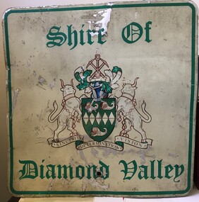
Sign - Boundary Sign, Shire of Diamond Valley, Shire of Diamond Valley boundary sign, 1990s
... Boundary Sign...Shire of Diamond Valley boundary sign...boundary signs... until 1994. This example of a Boundary Sign was one of many... Plenty Lower Plenty melbourne Boundary Sign Sign Shire of Diamond ...The Shire of Diamond Valley was a Local Government Area located about 20 kilometres northeast of Melbourne. The shire covered an area of 74.38 square kilometres and existed from 1964 until 1994. This example of a Boundary Sign was one of many located on the edge of the Shire e.g. at Wattle Glen Station; at Yan Yean Road north of Bannons Lane; 2 on Plenty Road near Larundel and Bundoora Primary School; one on the Para Road bridge; on Wattletree Road Eltham and on Kurrak Road Yarrambat. According to a former Shire employee, the signs were often stolen as quickly as they were replaced. This sign was removed when the Shire of Diamond Valley was dissolved in 1994 and is signed by a Shire employee, giving it strong provenance.Painted metal sign, cream background with green text and Shire of Diamond Valley crest.Inscribed in felt tip pen on back of sign: SDV: from Nov 1964 to 1994. 30 years. Ron Middleton, By-laws Officer and Ranger, from 9/84 to Nov 94 [signed] R. Middletonshire of diamond valley, boundary signs -
 Whitehorse Historical Society Inc.
Article, Reins to city, 1995
... boundary signs.... Commissioner, Geoff Oscar inspect the new boundary signs. City ...Whitehorse Council's Chief Executive Office, Dr Shirley Randall and Chief Commissioner, Geoff Oscar inspect the new boundary signs.Whitehorse Council's Chief Executive Office, Dr Shirley Randall and Chief Commissioner, Geoff Oscar inspect the new boundary signs.Whitehorse Council's Chief Executive Office, Dr Shirley Randall and Chief Commissioner, Geoff Oscar inspect the new boundary signs.city of whitehorse, logos, randell, shirley, oscar, geoff -
 Ballarat Tramway Museum
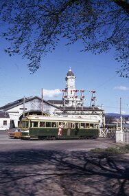
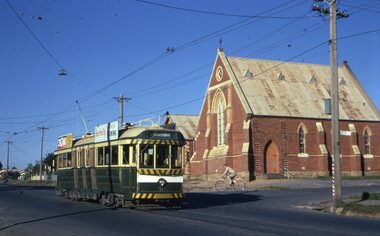
Slide - 35mm slide/s - set of 6, Campbell Duncan, 19/09/1971 12:00:00 AM
... with the Sebastopol boundary sign and Binks Ford in the background. Tram has... with the Sebastopol boundary sign and Binks Ford in the background. Tram has ...Yields information about the operations of the Ballarat Tramway system on the last day of SEC tramway operations in Ballarat.Set of 6 Kodak - Kodachrome slides - cardboard mounts - all taken on 19/9/1971, last day of operations prior to closure of the SEC operated tramway. .1 - Tram 40, waits at the level crossing gates - the gates are being opened. In the background is the station building and the signal gantry. Tram has the destination of Sebastopol. .2 - No. 42, with destination of Lydiard St north, northbound in Lydiard St, with railway station buildings and VRI in the background. .3 - No. 35 on inbound, Lydiard St North. .4 - No. 35, on inbound service, leaving Skipton St loop with another bogie in the background. .5 - No. 39 on inbound service, Albert St Sebastopol with the Sebastopol boundary sign and Binks Ford in the background. Tram has an everything under control in my all electric kitchen roof advert. .6 - No. 42, with destination of Sebastopol, Albert St Sebastopol.In ink on slide: .1 - Sun 19 Sept 71 - up Lydiard St Nth waits for gates to be opened after fast goods. .2 - Sun 19 Sept 1971, down Lydiard St Nth near VRI. .3 - Sun 19 Sept 1971, Up Lydiard St Nth .4 - Sun 19 Sept 1971, Up Sebastopol (supplementary service) has just crossed down in Skipton St near Drummond St. .5 - Sun 19 Sept 1971, Up Sebas at Ballarat / Sebastopol boundary. .6 - Sun 19 Sept 1971, c5.30pm down Sebas in Sebas shire.tramways, trams, lydiard st nth, railway station, level crossings, skipton st, albert st, sebastopol, closure, last day, tram 40, tram 42, tram 35, tram 39 -
 City of Moorabbin Historical Society (Operating the Box Cottage Museum)
Document, Photocopy Letter Stephen Charman to Michael Charman UK 1853, 1853
Stephen Charman, aged 21 years arrived in Melbourne in 1842 as one of Henry Dendy's emigrants. He established purchased land in 1852 and established a market garden at Spring Grove Cheltenham with his 2nd wife Mary nee Gettens. Stephen died 1906 in Gippsland. He wrote letters to his brother Michael who had remained in England Stephen and Mary Charman were pioneer market gardeners in Moorabbin Shire 1842 and were involved in the development of Church, school and community in the area now called Cheltenham. Charman Road Cheltenham was a boundary of their land. Letter, handwritten from Stephen Charman to his brother Michael in UK 1853 x 3 pages Handwritten signed Stephen early settlers, pioneers, spring grove, city of moorabbin, county of bourke, moorabbin roads board, parish of moorabbin, shire of moorabbin, henry dendy's special survey 1841, were j.b.; bent thomas, o'shannassy john, king richard, charman stephen, charman mary, gettens mary, marigold flowers, pharmacy, methodist church, state schools, education, highett william, ormond francis, maynard dennis, market gardens, -
 Wycheproof & District Historical Society Inc.
Bunguluke Map, Bunguluke District In 1923, 27.2.1923
By 1881 Bunguluke was a small settlement as recorded, December 5, in the Charlton "Mercury". It reports that in that year Draper's Store, Hotel and Post Office and residence at Bunguluke North was totally destroyed by fire. For years now there has been little sign of community life with houses few and far between and acreages have gone into larger holdings. The map references land blocks and owners for that era.This important map shows the local land ownership and local features that existed in 1923. This is a photocopied black and white map of Bunguluke in the County of Kara Kara, Number L5149. Marked - Photo Lithographed by W.J. Butson 27.2.1923. The details include numbers of allotments, property owners, roads, rivers. The boundaries marked are the Parish of Jeruk, Parish of Wycheproof, Parish of Cooroopajerrup. Wycheproof township location is shown with the Scale of Chains. Bunguluke maps for other years are also in the collection.map, bunguluke, jeruk, wycheproof, cooroopajerrup -
 Eltham District Historical Society Inc
Document - Folder, Dendy, 2012
Henry Dendy (1800-1881) was an early settler of Eltham where he operated a flour mill. He donated land for the construction of St Margaret's Anglican Church. EDHS Newsletter No. 168 May 2006 Dendy is best known as the founder of Brighton, but it is not so well known that years later he lived at Eltham for far longer than he lived at Brighton. In 1840 while still in England he bought eight square miles of unspecified land in the Port Phillip District. This entitled him to bring a number of other persons to the colony and in 1841 he arrived at Williamstown in the "York" with his family and 139 others. He took up his land entitlement at what is now Brighton and most of the emigrants settled there. He encountered financial problems and lost his interest in the estate in 1844. He left Brighton in 1847. He successively but not always successfully became a brewer at Geelong, a sheep farmer at Christmas Hills and Upper Moira, a flour miller at Eltham; a sheep farmer again at Werribee and finally a copper miner at Walhalla. Dendy came to Eltham in 1856 after having spent a year in England. The total of the two parcels of land that he bought was about 5 acres (2 hectares) and it included the steam flour mill. . He became prominent in local affairs, serving for a time on the Eltham District Road Board, including one year as President. Dendy' s wife Sarah died at Eltham in 1860 and also in that year he was appointed chairman of a committee to establish a Church of England in Eltham. He donated one of his Pitt Street lots for this purpose and St Margaret's was opened in 1861. In 1867 Dendy sold his mill to W. F. Ford and moved to Werribee and then Walhalla where he remained until his death. He is buried in the Walhalla cemetery. No sign of Dendy's house or mill remain on the Community Centre site but some of the old trees running along the former boundary through the centre of the site could well have been planted in Dendy' s time. Much of this information was obtained from the book ''Henry Dendy and his Emigrants" by L.A. Schumer (Sallas Books 1975). The Society has an extensive file of Dendy information, much of it provided by the late Leslie Schumer. Manilla folder of information. Includes Folder 88 from Harry Gilham Collection which includes EDHS tour notes of St Margaret's Anglican Church, Eltham, 2012, copy of newspaper article, Diamond Valley News, December 15, 1981, copy of newspaper article, The Advertiser, September 2, 1932, photocopy of photograph of graves at Walhalla Cemetery and Warringal Cemetery, photocopies, 6 pages from an unsourced book. henry dendy, st margaret's anglican church, catholic section, eltham cemetery, harry gilham collection, sarah dendy, walhalla cemetery -
 Nillumbik Shire Council
Artist Book: Tommaso DURANTE (b.1956 ITA, arrived. 2001 AUS) with text by Chris WALLACE-CRABBE (b.1934 AUS), Skin, Surfaces and Shadows, 2007
'Skin, Surfaces and Shadows' was created by Tommaso Durante in 2004 during his stay in Bundanon (gifted to the Australian people by Arthur & Yvonne Boyd - South East Australia) as international artist in residence and it was enriched during the artist’s stay in Broome (Western Australia) in 2005. On that occasion he collected the raw materials that were subsequently wrought to develop the actual bookwork.On the edge of artistic practice and philosophical inspiration, 'Skin, Surfaces and Shadows' pushes the boundaries of art, craft and design by combining digital technologies with traditional techniques and materials. Durante visually explores the surfaces of organic things (trees, surface textures, etc.) and the figurative dividing line of the shadow. The poet Wallace-Crabbe responds to these images in words. The poet and the artist flit in and out of shadows, skin and the surfaces of paper and life.(a) prints, artist's book (80 pages), ink; Somerset Book White paper (175gsm), digital images, printed in eight inkjet colour pigments, from digital files. Set in digital typefaces Utopia STD Display, Italic and Bold, Frutiger 57 Condensed, 67 Bold Condensed, and 56 Italic. Section sewn around 3 tapes. Full paper binding with blind blocking on front cover handmade head and tail bands. (b) CD of slide presentation to accompany bookwork on display Primary Insc: In black biro, signed and editioned by Tommaso Durante and Chris Wallace-Crabbe (last page '8/25 T DURANTE CWallace-Crabbe')prints, artist book, skin, surface, shadow, poetry, durante, wallace-crabbe -
 Puffing Billy Railway
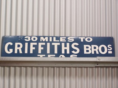
Sign - Advertising - Griffiths Tea Sign - 30 Miles, between 1879 - 1930's
In 1879, James Griffiths established one of Australia’s first tea and coffee distribution companies at 30 Flinders St, Melbourne, which is now, occupied by the boutique Lindrum Hotel. Established with his brother John, recent immigrants from England, Griffiths occupied the highest position in the commercial world during their many years as distributors of tea, coffee, cocoa and other products throughout Victoria and Australia. The Griffiths brand was a guarantee for quality of product and service as it still is today. This extensive service was provided to customers via horse drawn carts serviced by rail from Melbourne. As a spirited entrepreneur, Griffiths made his company a household name through his pioneering use of outdoor advertising by installing the infamous blue and white enamel “Griffiths Tea” promotional signs affixed to the railway boundary fences highlighting to travellers the distance to or from Melbourne, indicating so many “— miles to Griffiths Tea”. These signs, much sought after today, were well known through out the eastern states. Photographs have been published of a sign erected by a Digger in France during the First World War with the words “1100 miles to Griffiths Bros”. Tragically, James and his wife Emily with friends died in a level rail crossing accident at Bayswater in 1925. Despite this unfortunate accident, Griffiths and its culture of innovation has survived as one of the few 100% Australian owned coffee roasters, with only three owners in 128 years. http://www.griffithscoffee.com.au/about-us/back-to-1879/ Sign - Advertising - Griffiths Tea Sign - 30 MilesHistoric - Sign - Advertising - Griffiths Tea Sign - used along side of Victorian Railway lines and at StationsSign - Advertising - Griffiths Tea Sign - 30 Miles Griffiths Tea sign made of Enamel paint on metal sign30 Miles to Griffiths Tea Sign puffing billy, sign - advertising - griffiths tea sign - 30 miles -
 Hume City Civic Collection
Photograph, early 1990s
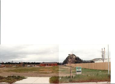
The series of 5 photographs feature different views of the Woodlands housing development which opened up land bounded by Gap and Anderson Roads, Cornish Street and Elizabeth Drive in the early 1990s. It was a large housing development built close to Sunbury township.A view of the northern boundary of the Woodlands housing development in Anderson Road. A paling fence divides the estate from the 'Malley' factory, now 'Storage King' which is on the corner of Cornish Street and Anderson Road. A 'For Sale' sign is in the foreground and a partly built house is in the middle distance.housing developments, anderson road, george evans collection -
 Eltham District Historical Society Inc
Photograph, Liz Pidgeon, Heritage Excursion; Maroondah Aqueduct, 3 September 2016
Newsletter No., 229, August 2016 Heritage Excursion - Maroondah Aqueduct Walk - Saturday 3rd September The Maroondah Aqueduct was once a major link in Melbourne’s water supply system. It was built between 1886 and 1891 to transfer water from the Watts River near Healesville to the Preston Reservoir. It was 66 km in length, made up of 41 km of open channel, 10 km of tunnel through hills and 15 km of pipeline across stream valleys known as inverted siphons. The section of the aqueduct through the Eltham area has been abandoned since the 1980s but the open channel has largely been retained. A recreational path follows the aqueduct reserve. For our excursion on 3rd September we intend to walk along the section of the aqueduct adjacent to Allendale Road. This is a section not visited on previous excursions and includes the transition from open channel to the inverted siphon across the Diamond Creek valley. Apart from the aqueduct itself the main feature of the walk is the extensive views across Eltham North and Diamond Creek. Along the way we will talk about the history of the aqueduct and the area. This easy walk is about 3 km return and will take 2 to 2.5 hours. It will start at 2pm at the junction of Allendale Road with Godber Road and Zig Zag Road North, officially Diamond Creek, but on the northern boundary of Eltham. (Melway ref.12 B10). Born Digitalmaroondah aqueduct, eltham north, activities, eltham district historical society, heritage excursion, acqueduct trail, sign -
 Eltham District Historical Society Inc
Photograph, Liz Pidgeon, Heritage Excursion; Maroondah Aqueduct, 3 September 2016
Intersection with local Street signs Newsletter No., 229, August 2016 Heritage Excursion - Maroondah Aqueduct Walk - Saturday 3rd September The Maroondah Aqueduct was once a major link in Melbourne’s water supply system. It was built between 1886 and 1891 to transfer water from the Watts River near Healesville to the Preston Reservoir. It was 66 km in length, made up of 41 km of open channel, 10 km of tunnel through hills and 15 km of pipeline across stream valleys known as inverted siphons. The section of the aqueduct through the Eltham area has been abandoned since the 1980s but the open channel has largely been retained. A recreational path follows the aqueduct reserve. For our excursion on 3rd September we intend to walk along the section of the aqueduct adjacent to Allendale Road. This is a section not visited on previous excursions and includes the transition from open channel to the inverted siphon across the Diamond Creek valley. Apart from the aqueduct itself the main feature of the walk is the extensive views across Eltham North and Diamond Creek. Along the way we will talk about the history of the aqueduct and the area. This easy walk is about 3 km return and will take 2 to 2.5 hours. It will start at 2pm at the junction of Allendale Road with Godber Road and Zig Zag Road North, officially Diamond Creek, but on the northern boundary of Eltham. (Melway ref.12 B10). Born Digitalmaroondah aqueduct, eltham north, activities, eltham district historical society, heritage excursion, street signs, acqueduct trail, allendale rd, godber rd, zig zag road, intersection -
 Eltham District Historical Society Inc
Photograph, Liz Pidgeon, Heritage Excursion; Maroondah Aqueduct, 3 September 2016
Sign for Yarra Valley Water at Diamond Creek property Newsletter No., 229, August 2016 Heritage Excursion - Maroondah Aqueduct Walk - Saturday 3rd September The Maroondah Aqueduct was once a major link in Melbourne’s water supply system. It was built between 1886 and 1891 to transfer water from the Watts River near Healesville to the Preston Reservoir. It was 66 km in length, made up of 41 km of open channel, 10 km of tunnel through hills and 15 km of pipeline across stream valleys known as inverted siphons. The section of the aqueduct through the Eltham area has been abandoned since the 1980s but the open channel has largely been retained. A recreational path follows the aqueduct reserve. For our excursion on 3rd September we intend to walk along the section of the aqueduct adjacent to Allendale Road. This is a section not visited on previous excursions and includes the transition from open channel to the inverted siphon across the Diamond Creek valley. Apart from the aqueduct itself the main feature of the walk is the extensive views across Eltham North and Diamond Creek. Along the way we will talk about the history of the aqueduct and the area. This easy walk is about 3 km return and will take 2 to 2.5 hours. It will start at 2pm at the junction of Allendale Road with Godber Road and Zig Zag Road North, officially Diamond Creek, but on the northern boundary of Eltham. (Melway ref.12 B10). Born Digitalmaroondah aqueduct, eltham north, activities, eltham district historical society, heritage excursion, diamond creek, yarra valley water, sign -
Port Melbourne Historical & Preservation Society
Plan - Metalling and channelling Evans Street from Ingles Street to Boundary Street, 14 Mar 1893
Specifications (94.1) and Plan (94.2) for metalling and channelling Evans Street from Ingles Street to Boundary Street . Loan Works 1893. Plan number 8.Both signed by J.J. Bartlett. (Mayor).engineering - roads streets lanes and footpaths, town planning, town clerks, mayors, arthur victor heath, james john bartlett -
Port Melbourne Historical & Preservation Society
Document - Specification, Metalling and chanelling, Danks Street from Esplanade East to Boundary Street South, Engineering Department, Town of Port Melbourne, 14 Mar 1893
Specification for metalling and channelling Danks Street from Esplanade East to Boundary Street South (Pickles Street) Loan Works 1893 plan 19; relates to plan 98.2Signed by JJ Bartlett (Mayor) 14.3.1893engineering - roads streets lanes and footpaths, town planning, town clerks, mayors, arthur victor heath, james john bartlett -
Port Melbourne Historical & Preservation Society
Plan - Metalling and channelling Danks Street from Esplanade East to Boundary Street South, Engineering Department, Town of Port Melbourne, 14 Mar 1893
Plan for metalling and channelling Danks Street from Esplanade East to Boundary Street South (Pickles Street) Loan Works 1893 plan 19; relates to specification 98.1Signed by JJ Bartlett (Mayor) 14.3.1893engineering - roads streets lanes and footpaths, town planning, town clerks, mayors, arthur victor heath, james john bartlett -
 Ballarat Tramway Museum
Slide - 35mm slide/s - set of 20, Noel Simons, 21/05/1971 12:00:00 AM
... Gully. On left hand side is the City of Bendigo sign... and California Gully. On left hand side is the City of Bendigo sign ...Set of 20 transparencies taken on 21/5/1971 on Kodak mounts. 1197.1 - Bendigo No. 5 en route to Eaglehawk at Creeth St Long Gully. Tram has a SEC roof ad and Cinzano roof ad. 1197.2 - No 5 approaching Needle Loop between Long Gully and California Gully. On left hand side is the City of Bendigo sign, indicating city boundary. 1197.3 - As for 1197.2 but actually entering loop. Photo taken after tram has passed photographer. 1197.4 - No. 26 bound for Eaglehawk descending the railway bridge near Eaglehawk, at Jobs Gully. 1197.5 - as for 1197.4, but after crossing bridge, now ascending a hill. Photo taken after tram has passed photographer. 1197.6 - No. 26 climbing High St. hill Eaglehawk, nearing end of Double track, bound for Quarry Hill. Shows centre of the road poles. 1197.7 - As for 1197.6, with tram entering single track section. Photo taken after tram has passed photographer. Has a BP service station in the background. 1197.8 - No. 26 (bound for Quarry Hill) crossing No. 17 (Eaglehawk) at Job's Gully Loop. 1197.9 - No. 17 climbing railway bridge at Job's Gully, en route to Eaglehawk. Photo taken after tram has passed photographer. 1197.10 - No.26 bound for Quarry Hill, leaving Long Gully Loop? Has the Creeth St. church in l197.l in the far background. Photo taken after tram has passed photographer. 1197.11 - Tramway Point work at the northern end of Long Gully Loop. 1197.12 - No. 17 en route for Quarry Hill turning into View St. from Bamard St. Tram has SEC roof ads "Everything fine in my all electric Kitchen' and 'Electric Cooking is Matchless'. 1197.13 - as for 1197.12, but tram has turned into View St and about to enter the double line track. Photo taken after tram has passed photographer. 1197.14 - No. 21 enters Nolan St after turning from MacRae St. en route to Bendigo. Note sign on its own post noting tram turns "Beware Tram Turns" and stop sign on adjacent pole "Trams stop on Request". No. 21 has two SEC roof ads. 1197.15 - No. 21 in Nolan St. after turning from Bridge St. (White Hills Road). Note signal light for Bridge St. loop on pole corner of street. Photo taken after tram has passed photographer. 1197.16 - No. 2 bound for Eaglehawk at unknown location. 1197.17 - Tram stop sign on a pole "CARS STOP BY REQUEST" 1197.18 - No. 5 in Carpenter St.? en route to Quarry Hill. 1197.19 - No. 28 has just arrive at Golden Square terminus, passengers are disembarking and the trolley pole is being turned. Golden Square Hotel in the background. 1197.20 - No. 28 at Golden Square terminus. Has a "Nothing beats Briquettes for hear roof ad. Information written on in black ink and date stamped on purple ink. 1197.1 - "No. 5 at Creeth St. Long Gully" 1197.2 - "No. 5 approaching Needle Loop between Long Gully and California Gully" 1197.3 - "No. 5 at Needle Loop between Long Gully and California Gully" 1197.4 - "No. 26 crossing railway bridge at Job's Gully near Eaglehawk" 1197.5 - "No. 26 just after crossing railway bridge at Job's Gully near Eaglehawk/ 1197.6 - "No. 26 in High St. Eaglehawk" 1197.7 - "No. 26 at end of double track in High St. Eaglehawk" 1197.8 - "Nos. 26 and 17 crossing at Job's Gully Loop" 1197.9 - "No. 17 crossing railway bridge at Job's Gully near Eaglehawk". 1197.10 - "No. 26 at Long Gully" 1197.11 - 'Northern end of points at Long Gully Loop". 1197.12 - "No. 17 turning into View St. from Bamard St. Bendigo". 1197.13 -'No. 17 at beginning of double track in View St. after leaving Bamard St. Bendigo. 1197.14 - "No. 21 enters Nolan St. from MacRae St. Bendigo." 1197.15 - "No. 21 in Nolan St. Bendigo just after leaving White Hills Road." 1197.16 - "No. 2" 1197.18 - "No. 5" 1197.19 - "Birney car No. 28 at Golden Square Terminus" 1197.20 "Birney car No. 28 at Golden Square Terminus" tramways, trams, bendigo, long gully, railway bridge, jobs gully, trackwork, nolan st, quarry hill, tram stops, golden square, tram 2, tram 5, tram 17, tram 21, tram 26, tram 28 -
Glen Eira Historical Society
Document - History of the City of Caulfield
This file contains 4 items: 1/Typewritten document titled ‘The City of Caulfield’. Author and date unknown. 1 page (back and front), 2 copies. Document covers topics such as origins of the name ‘Caulfield’, early settlement and the Caulfield Cup. 2/Typewritten document titled ‘History of Caulfield Council’. Author and date unknown. 6 pages, 3 copies. Document covers subjects such as early settlement, Aboriginal influence, Caulfield Road Board, Shire of Caulfield, Borough and town boundaries, coat of arms, and Freedom of Entry to the City. 3/Typewritten document (undated + author unknown) titled ‘The Structure of Local Government in Victoria with a history of the City of Caulfield’. 13 pages. Covers the following subjects: Powers, Planning, Public Works, Trading Undertakings, Health Services, Municipalities, Wards Electors or Ratepayers, Voters Roll, Councillors, Officers, Finance, Nature of Soil and Vegetation, Parks and Gardens and Reserves, Coat of Arms, Boundaries, How Did Caulfield get its Name, Aboriginal Influence, Caulfield Road Board, Shire of Caulfield, Borough and Town and the City of Caulfield. Also covered is early settlement. Note at the end of the document mentions that the historical content contained in the last section was based upon a thesis for the Department of Town and Regional Planning, University of Melbourne, 1968 by L. Alwis, P. Rowe, N. Wootten. Melbourne, ‘City of Caulfield: An Illustrated City Report’. 4/Typewritten document (undated) titled ‘The Structure of Local Government in Victoria with notes on the history of the City of Caulfield’. 8 pages, 2 copies. This document also includes a map/diagram of the city with boundaries and wards showing locations of railway stations and parks. Document covers the structure of local government and its functions then goes on to focus on City of Caulfield with subjects similar to those covered in item 3. Document signed off by Deputy Town Clerk.city of caulfield, caulfield john, caulfield baron, caulfield racecourse, elsternwick, ripponlea, st. mary’s church, caulfield council, kooyong road, neerim road, bambra road, greenmeadows house, caulfield park, paddy’s swamp, dandenong road, caulfield grammar school, chisholm institute of technology, murrumbeena, glen eira road, alma road, orrong road, balaclava road, inkerman road, ‘grosmont’, caulfield school room, caulfield road board, caulfield road district, crimean war, victorian amateur turf club, caulfield cup, glenhuntly road, north road, glenhuntly station, ormond station, outer circle railway, local government, gardenvale, carnegie, rosstown, poath road, nepean highway, hotham street, ormond park, princes park, ross william murray, caulfield institute of technology, ‘ross’ folly’, hawthorn road, glenhuntly, ormond, morris t. w., lloyd charles du plan, meals on wheels, shire of caulfield, caulfield railway station, caulfield rsl, bouran road, murrum murrumbeen, kooyong road, great dandenong road, neerim road, trams, prahran and malvern tramways trust, fisher andrew, mackinnon reserve, dover street, ‘glen eira’, blair max cr., insignia, third ordnance services unit, schools, street lighting, lampriere, mr. bevan, the caulfield leader, davies j. henry, curraweena road, st. georges road, o’neill college, hope george, market gardens, koornang reserve, packer reserve, murrumbeena reserve, hopetoun gardens, greenmeadows gardens, mirambeena, caulfield technical college, hart john, langdon h. j., ‘rosecraddock’, judge webb, ‘crotonhurst’, service james, ‘kilwinning’, ricketson henry, grimwade frederick sheppard, airdrie, jenner, st. aubin’s, caulfield john p. t., harlston, lempriere, lord reserve, ‘cantala’ -
 Glen Eira Historical Society
Letter - Eastleigh Community Church, East Boundary Road, 216
Two items about this Church: 1/ Printed Email from Brian Walsh, giving brief details of his time at Eastleigh Community Church and McKinnon Gospel Hall dated 21/04/2010 and Reply dated 03/06/2012. 2/ 3 digital photos taken on 20/02/2010 by Claire Barton for GEHS project: 2 different views of the street frontage for the Church and 1 view of the sign on the front wall.pearson bob, deakin street, mckinnon, eastleigh community church, bentleigh east, eastleigh gospel chapel, walsh brian, coates lindsay, mckinnon gospel hall, east boundary road, bent street -
 Bendigo Historical Society Inc.
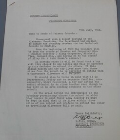
Document - Technical school in Bendigo
Typewritten letter from the Bendigo Inspectorate placement committee to the heads of Primary schools advising them of the change to the boundary between the two technical school. Attached to the letter two drawing showing in the first the area covered by the white Hills technical school and the Kangaroo Flat technical school and in the second the Bendigo, Golden Square and Eaglehawk High School boundaries. The letter is dated 19th July 1968 and signed by W.F.R Budge (District Inspector of Schools) Aileen and John Ellison Collection.technical school, white hills technical, kangaroo flat technical -
 Falls Creek Historical Society
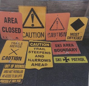
Sign - Falls Creek Ski Patrol
The first ski patroller in Falls Creek was Brian Caddy with two casual ski patrollers Rob Sarroff and David Crooke in the 1960s. In 1972 the “official” Falls Creek Ski Patrol was created under the advisement of Dr Rodney Moss with the support of the Management Committee. By 1977 there were six or seven patrollers, and currently there are around 40 patrollers on the team with 13-14 rostered on each day during peak season. In 1974 the Australian Ski Patrol Association (ASPA) was formed. On the 14th March 1975, the Falls Creek Tourist Area Management Committee applied for membership to ASPA. At that time, Falls Creek Ski Patrol was known as Falls Creek Ski Rescue. From that time, Falls Creek patrollers began wearing the recommended uniform of a white cross on a red parka.These signs are significant as they are representative of the work carried out by Falls Creek Ski Patrol to keep skiers safe.A variety of signs used by Falls Creek Ski Patrol to alert tourists to conditions on the mountains in the area.A range of words and symbols including:- AREA CLOSED CAUTION MOST DIFFICULT TRAILS MERGE - CAUTION CAUTION TRAIL STEEPENS AND NARROWS AHEAD SKI AREA BOUNDARY SKI PATROL OUT OF BOUNDS / AREA NOT PATROLLED / NO ACCESS TO SKI LIFTS / PROCEED AT OWN RISKfalls creek ski patrol, skiing safety -
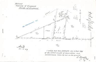
 Ringwood and District Historical Society
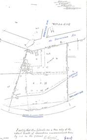
Document - Copy of Lands Department Field Notes - Parish of Ringwood, Victoria, Field Notes - OP34838 - surveyed in 1919 by D. Barker
5615b Foolscap size photocopy of survey map with handwritten notations. References include Braeside Avenue, Mount Dandenong Road, Rosedale Court, Railway Avenue, cyclone fence, Sec A, WB house, old tennis court netted, stable, old shed, tank stand, orchard, Township Boundary, netting fence, Railway fence, Ringwood to Lilydale Railway, I certify that these fieldnotes are a true copy of the actual results of observations & measurements taken by me on the ground (signed) D. Barker (1919). -
 Ringwood and District Historical Society
Document - Copy of Lands Department Field Notes - Parish of Ringwood, Victoria, Field Notes 1917/148 - Part of O.P. R72 - Crown Allotment 10, surveyed June 1917
5614b Foolscap size photocopy of survey map with handwritten notations. References include Wantirna Road, to Ringwood Station, Reilly Street, J. Marshall, fence to be erected on boundary, I certify that these notes are a true copy of observations and measurements made on the ground by me (signed) H.W. Moore 22/6/17. -
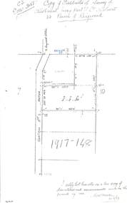
 Ringwood and District Historical Society
Document - Copy of Lands Department Field Notes - Parish of Ringwood, Victoria, Field Notes 1909/174 - Part of O.P. R72D surveyed 12.3.1909
Foolscap size photocopy of survey map with handwritten notations. References include Mount Dandenong Road, pathway, 2 room house, scillion, shed, WC, 17C sold, Cr lands, orchard, 17E sold, Township boundary, I certify that these field notes are a true copy of the actual results of observations and measurements taken by me on the ground (signed) D. Barker 12.3.09. -
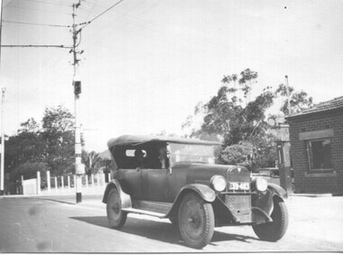 Melbourne Tram Museum
Photograph - 1926 Hudson Super 6 - Riversdale and Warragul Roads, Ray Pearson, 1930s
Photograph of a 1926 Hudson Super 6 parked at the tea room/kiosk on the intersection of Riversdale Road and Warragul Road. Distinguishing features of the car include the triangular badge on the radiator and the unusual disc wheels. The 1926 Hudson also had horizontal radiator shutters. On this vehicle, a finer mesh has been attached in front of the shutters. This is normal practice when insects such as locusts are in plague. At the time, Warragul Road was known as East Boundary Road. Behind the car on the tramway pole is a colour light tramway signal for the single-line section between Warragul Road and the terminus. On 1 July 1928, the Wattle Park line was extended from Boundary Road via Riversdale Road to Elgar Road. It was built as a single track with a passing loop about halfway along, plus a passing loop at the former Boundary Road terminus. The tramway pole has a stop sign and a telephone box as well. In a box of negatives received is an envelope noting the car was owned by Ray Pearson and photo taken during the 1930s. Inside the motor car are two people, the driver, and a lady. In the background is part of the tea rooms located at this corner with a Shell gravity-fed petrol bowser. At the time, petrol was not sold at Service Stations on a Sunday - Sunday trading laws, but they allowed Tea Rooms or kiosks to be open.Yields information the intersection of Warragul and Riversdale Road and MMTB single line signals.Black and white photograph on Velox paper.On rear in pencil "Colour light signal Wattle Park Route, down end loop line, corner of Riversdale and East Boundary Roads".trams, tramways, riversdale road, wattle park, warragul road, motor cars, hudson super 6, shell fuel, signalling, single line, ray pearson -
 Ballarat Tramway Museum
Map, Electric Supply Co. of Vic (ESCo), Ballarat Electoral Map - ESCo, 1900
Document prepared by the Electric Supply Co of Victoria, as part of an order under the Electric Light and Power Act 1896, section 5 of order No. 17 granted to company. Dated 19/2/1901 and signed by the Postmaster-General. Shows the order area being parts of the City of Ballaarat, Sebastopol and Ballarat East. Shows the street names, boundaries, principal power line routes, land reserves, parks, mine locations, railways and Lake Wendouree. Signed by R L Williams Town Clerk City of Ballarat, J R Hall for the Borough of Sebastopol, and John Gent for the Town of Ballarat EastYields information about the power supply to the Ballarat area.Cloth backed paper map, coloured and marked up as exhibit 17.Notes in ink including the signature of Benjamin Deakin 24/9/00 and certified by the three involved municipal Town Clerks.ballarat power supply, esco, electric supply co of victoria, city of ballaarat, east ballarat, sebastopol, orders, power lines, power supply -
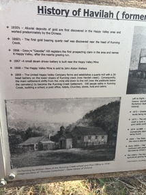 Kiewa Valley Historical Society
Papers - Havilah Cemetery, Havilah Cemetery Formerly Running Creek Cemetery
In 1889, 24 residents of the Running Creek and surrounding district submitted a petition to the Minister of Lands, Melbourne requesting land for a cemetery. Their request was granted. The Cemetery was decommissioned in the early 1950s and the last trustee for the cemetery died in 1986. There is a wooden fence around the boundary (May 2024). One paper lists 29 names in the Burial Register 1861-1948. The last two sheets record the history as a timeline from the 1850s to the 1900s. Havilah was a gold mining settlement from the 1850s located 20km west of the Kiewa Valley and in the Ovens catchment near Myrtleford.Five black and white A4 pages stapled together. Copies of the sign erected at the gate of 'Havilah cemetery formerly Running Creek Cemetery'. Also the 'History of Havilah formerly Running Creek'havilah, running creek, cemetery